Anastasiia Satarenko Senior Design Researcher
Digital Solutions for Urban Planning and Reconstruction

- #Architecture
• 26 min read
Introduction
Reconstructing damaged residential areas is one of Ukraine's government objectives. Entire cities will have to be rebuilt almost from scratch. Although there is a natural tendency to restore cities as they were, one should try not to rebuild residential buildings and infrastructure in the Soviet style. Reconstruction should prioritize using the latest advances in construction technologies (focusing on energy efficiency), design, and urban planning. It is necessary to find a balance between "old" and "new" ("smart," "green") cities.
As a TR&D team, we look for possible solutions to help with that objective and generate more ideas for renovation improvements.
History of post-war reconstruction
Here, we will look at a few countries affected by wars in the past and walk through the issues they faced in reconstruction projects, analyzing what we should consider now.
Dubrovnik

The siege of Dubrovnik was a military engagement between the Yugoslav People's Army and the Croatian forces defending the city of Dubrovnik and its surroundings during the Croatian War of Independence.
Dubrovnik had been an important tourist destination for so many decades before the outbreak of ethnic conflict in 1992, and for years the town was on the World Heritage List. Many people inside the city assumed that their fair-weather friends and investors would return during their time of the greatest need to assist the municipality in rebuilding itself physically and socially. This assumption turned out to be wrong. It was years before any significant and coordinated foreign aid reached Dubrovnik, long after its residents had already addressed many of the most pressing reconstruction issues piecemeal.
Croatian authorities created or improved local mechanisms through which large-scale reconstruction projects could be implemented, putting themselves in a good position to orchestrate the ongoing projects required to return to some normal state of civic affairs.
Issues:
- Relying too much on foreign partners
- Having limited local recourses working in a short time span
- No public input
Coventry

The Coventry Blitz was a series of bombing raids on the British city of Coventry. When it came to reconstruction, it failed simultaneously in several ways: It was grounded on unreliable assumptions about the city's growth and its residents' social behavior. It buried a past that still had psychological value to local communities. It imposed a highly integrated urban aesthetic that owed more to fashion than pragmatism.
Coventry rebuilding showcased how popular reconstruction plans can backfire when generated quickly by a few like-minded professionals without significant public consultation.
Issues:
- Plans approved by a small number of professionals
- No public consultation
- No ground research before planning
- Forgetting about the past that was important to locals
- Design for aesthetic instead of practical usage
Warsaw

Warsaw represents an outstanding example of political, social, and ideological reconstruction in response to its systematic destruction by the Nazis, who planned to erase the city's historical and cultural traces. They also planned to rebuild the city, replacing it with a much smaller German town without its original Polish and Jewish features.
Later on, after its liberation, Warsaw went through a symbolic reconstruction process that was taken to the extreme of rebuilding the Old City precisely as it looked before the war. In the rebuilding of other European bombed cities, an international style was very much visible, resulting in a loss of identity and character.
"The reconstruction of historic Warsaw satisfied a social need that was not of a material, but of psychological nature. The rebuilding of the Old Town was a protest of the Polish people against the brutal, destructive forces of Fascism. In the eyes of the inhabitants of Warsaw, it symbolized the historical continuity and everlasting life of their city, the city of their parents and children".
Issues:
The "One style for all" reconstruction approach results in the loss of identity in some cities
Lessons learned:
Restoration should take into account the cultural origins Engagement of the locals can work as a psychological group therapy
Guidelines for post-war urban reconstruction activities
The participants of the Second International Workshop on Settlement Reconstruction Post-War in 1989 developed specific guidelines for urban reconstruction activities.
Major points
- Maximizing locally available recourses (labor, skills, building materials, institutions, leadership) is vital:
- In addition to the active involvement of the local population in the reconstruction process, people should also be consulted in the decision-making phase. Inevitably, this slows down the overall process, but the social gains will likely be well worth such minor hold-ups. Planning should revolve around people rather than expect people to fit in with predetermined plans.
- Inventory of recourses available for reconstruction (building materials, skills, labor, local leadership, local institutions, assistance programs, and training institutions) is one of the initial steps.
- When local inventories of recoursed are complete, it becomes possible to determine unmet needs where international assistance can be involved.
- Effective reconstruction will only occur when it is comprehensive in its scope, and clearly defines the following:
- Immediate post-war planning activities
- Assessment of needs and damage
- Planning process
- Private and public roles in reconstruction
- Implementation of reconstruction
- Long-term planning reconstruction
- Information about the victims and damages (consider demographics, gender, age, employment, and social status)
- Assessment of the status (relocated survivors)
- Damage assessment
- Assessment of deficits (building, maintenance)
-
Planning should be flexible: numerous matters will surface while the design process continues, which presents the need for a high level of flexibility.
-
The timing of actions is critical. Reconstruction must be timed to relate to when people have returned to their locality following war evacuation, which should include:
- Incentives to encourage the return of residents to their locality
- Planning during the war
-
If the reconstruction is delayed to await the political and economic reforms, there is a risk of losing the momentum for action, so its planning should start immediately.
-
There are limited opportunities to reform the design of buildings and settlement patterns in reconstruction.
-
It is vital to preserve cultural heritage in reconstruction.
-
It is essential to introduce safety measures in reconstruction.
-
It will be possible to adapt sectors of the war economy to reconstruction targets.
-
The needs of handicapped people must be catered to.
-
Reconstruction should be regarded as therapy.
-
Knowledge needs to be documented.
General insights
-
People are the principal factor in recovery and reconstruction. Public participation in decision-making is a human right, a political duty, and an instrument essential for post-war reconstruction.
-
To better identify resources, both existing and potential, it is helpful to think of resources in terms of types: (1) human; (2) material or physical: (3) services, and (4) financial or credit ones.
-
Surprisingly, almost all the case studies have shown that people can be mobilized for reconstruction using the same machinery that mobilized them for war, like official propaganda machines.
-
Often an obstacle for any reconstruction strategy is the lack of trained professionals: policymakers, economic and physical planners, architects, engineers, managers, local leaders, public work officials, credit administrators, producers, builders, and intermediate personnel to assemble information on the population and its disruption.
-
In the rebuilding of the European bombed cities, an international style was very much visible, resulting in their loss of identity and character.
-
"The experiences of thirty years post-war city development and architecture had created a complete change of mind. Interest in the human values of heritage and environmental awareness has risen enormously" (Breitling 1983:64).
-
"The great mistake of reconstruction in Europe after WW2 was that these elementary human requirements were not taken into account" (Euggn Gross, 1983:3).
-
Speed in reconstruction is bound to affect the quality of life and the role of the local population.
-
Because of the great demand for housing that the state could not meet on its own, encouragement was given in the USSR to urban citizens to rebuild their houses (rural populations had to reconstruct their own houses anyway). A popular pamphlet 'How to Build Your Own House' was widely distributed. It has been claimed that almost 15% of the reconstructed urban houses were built by this method.
-
Reconstruction should be carefully documented and evaluated, and its results published periodically in various forms and places. This is needed to manage reconstruction better and transfer the experience to the public (to encourage participation), academic communities (for theoretical development), and practitioners in other countries and the future.
-
The best time to plan reconstruction is during the war to prepare the nation for a considerable jump in reconstruction activity when the war is over.
-
The more significant the role of the survivors in different reconstruction activities, the greater the chance of a rapid psychological recovery. Public participation is the only way to achieve cultural continuity in the reconstructed settlements. Participation is crucial for enabling people to manage and look after their environment and, subsequently, to achieve sustainable reconstruction.
Approach to modern cities
Nowadays, architects prefer the people-centered approach, where human issues are essential to successful city planning. Developing cities that are Lively, Safe, Sustainable, and Healthy is vital. The urban landscape must be considered through the five human senses and experienced at the speed of walking rather than at the speed of riding in a car, bus, or train. One of the most popular books on the topic — Cities for People by Jan Gehl — expands this in the greatest detail.
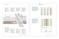
Global Design Street Guide
The Global Designing Cities Initiative (GDCI) focuses on the critical role of streets within urban environments worldwide. In partnership with the National Association of City Transportation Officials (NACTO) and the Global Expert Network, the GDCI is committed to sharing industry best practices, facilitating peer-to-peer mentoring, and fostering regular communication. The GDCI facilitates the exchange of ideas to help various stakeholders shape streets to promote public health and safety, quality of life, multimodal mobility, economic development, environmental sustainability, and equity.
In 2016 the GDCI created a Global Design Street Guide to reach targeted audiences — scientists, policymakers, environmental advocates, urban planners, the media, and concerned citizens — with information that can be used to create the framework for long-term ecological health and well-being.
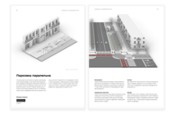
Planning guide for Ukraine
Although, together with taking into account foreign suggestions, we Ukrainians need to center on our citizens' needs and desires, taking into account our mentality and cultural background, which are expectedly different from other countries. A Ukrainian company, Urbanyna, is now creating a local guide that specializes in the urban aspect of city planning and considers human needs in the city to make it more comfortable for its citizens.

The main difference between the Global Design Street Guide and the guide for Ukraine is that the second one is adapted to the reality of Ukrainian cities and government regulations. All the materials in the guide are 3d-modeled, which allows to use them as a basis for a "constuctor"-style city planner. As in this guide all the measures are adapted to our government guidelines, it speeds up the work on planning for our architects and also takes the learning curve for foreign architects out of the equation. Invited architects who speak on modern city planning are usually unfamiliar with Ukrainian guidelines, way of life, and resources, so some solutions are difficult to apply to our context.
Smart cities
A smart city is a municipality that uses information and communication technologies to increase operational efficiency, share information with the public and improve the quality of government services and citizen welfare.
Several major characteristics are used to determine a city's smartness:
- a technology-based infrastructure
- environmental initiatives
- a high-functioning public transportation system
- a confident sense of urban planning, and
- humans live and work within the city and utilize its resources
Smart cities use a combination of the Internet of Things (IoT) devices, software solutions, user interfaces (UI), and communication networks. However, they rely first and foremost on the IoT, a network of connected devices — such as vehicles, sensors, or home appliances — that can communicate and exchange data.
Other smart city technologies include:
- application programming interfaces (APIs)
- artificial intelligence (AI)
- cloud computing
- dashboards
- machine learning (ML)
- machine to machine (M2M)
- mesh networks
Emerging trends such as automation, machine learning, and IoT drive smart city adoption.
Singapore
To optimize transport efficiency by using sensor technology, the Agency for Science, Technology, and Research (A*Star) has created an autonomous fleet to help the city's elderly and disabled residents stay mobile. The trial has reduced the rate of overcrowded buses by 92%.

The city also has a digital national identity system, a Smart National Sensor Platform, and Virtual Singapore — a 3D digital model of the city that can run simulations and support future planning — to name just a few hi-tech innovations.
Copenhagen
The incubator Copenhagen Solutions Lab was awarded in 2017 for a system that monitors traffic, air quality, waste management, energy use, and other items and compares operations in real-time. It connects electric vehicles' parking systems, traffic lights, buildings, smart metering, and charging systems to direct traffic in real-time and optimize energy use according to fuel prices, traffic movement, and weather. The ability to analyze, measure, and compare all of this data is meant to drive better efficiency in delivering services.

Hong Kong
One attractive feature is a new mobile-friendly city dashboard screen. It uses data gathered from various government departments to show real-time images, maps, icons, and charts of information such as average traffic speed in different districts and tunnels and temperature, rainfall, or parking availability. As it develops, more data from buses and trains will be added.

Existing projects & technologies used
Modern technology can contribute also to a smaller-scale projects for urban planning, below we outline a few focused project examples.
Artificial neural networks
Researchers have applied machine learning models to generate 2D drawings with pixels or 3D models with voxels, but pixelization reduces the precision of the geometries. Therefore, to learn and generate 3D geometries as vectorized models with higher precision and faster computation speed, they develop a specific artificial neural network, learning and generating design features for the forms of buildings. A customized data structure with feature parameters is constructed, meeting the requirements of the neural network by rebuilding surfaces with controlling points and appending additional input neurons as quantified vectors to describe the properties of the design. The neural network is first trained with generated design data and then tested by adjusting the feature parameters.
From IoT platforms to digital twins
How cities are designed, upgraded, and managed is about to fundamentally change due to the emergence of urban 3D modeling and generative design. The smart cities problem has mainly been dominated by the Internet of Things paradigm, attaching connected sensors to the built urban environment, including buildings, road infrastructure, and utilities, allowing optimized management, preventive maintenance, and other types of efficiency improvements and cost savings.

However, adding an IoT platform to Operational Technology (OT) infrastructure, by definition, only represents an incremental step toward managing existing urban assets more efficiently. Something far bigger is now appearing on the horizon in the form of holistic real-time modeling (digital twins of entire cities) and the automated, generative design of brownfield and greenfield urban environments. Modeling cities and optimizing operations through digital twins is great; designing them from scratch with Artificial Intelligence (AI) tools is better.
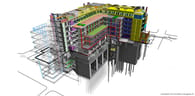
BIM
The now well-known concept of digital mockups, which specialists have labeled building information modeling (BIM), is being deployed more widely in the construction world today. In brief, it does away with paper drawings in favor of computerized 3D plans. BIM consists of a suite of processes that track the life of a building from its design, through the construction phase, to its eventual use. Virtual modeling makes it possible to carry out analyses, measurements, and simulations on its essential functions, whether in terms of its structural performance or its energy consumption — and enables real-time collaboration and coordination between everyone involved in the project.
AI and the Big Data
Construction AI uses machine learning to identify earthworks features on a PDF and exports the data it finds to DXF and PDF formats. Users can instantly get a site model and upload it to Trimble Business Center, AgTek, or Viewpoint Earthwork.
Construction AI's technology can generate a point cloud directly from a vector PDF containing existing spot elevations. Processing does not require any user inputs, and the information is exported to DXF with layers separated by confidence score — and directly integrates with your takeoff software.
Their predictive layering technology turns non-layered vector PDF files into layered files that can be exported as PDF or DXF. Construction AI's layering technology goes beyond simply grouping objects by object color or line width and provides users with more intelligently grouped data, which allows for quick and easy layering, which helps them build their site models faster.
Construction AI uses machine learning to automatically count Catch Basins, Lawn Basins, Access Holes, and Connections directly from a storm drawing without user inputs. While existing counting tools automate part of the counting process, Construction AI's counting feature can detect and classify symbols autonomously and at scale without any user input.

Another construction intelligence company launched in 2017 with the promise that its robots and artificial intelligence hold the key to solving late and over-budget construction projects. The company uses robots to capture 3D scans of construction sites autonomously and then feeds that data into a deep neural network that classifies how far along different sub-projects are. If things seem off track, the management team can step in to deal with small problems before they become major issues.
Boston Dynamics
Its robots can autonomously capture 3D scans of construction sites and then feed that data into a deep neural network:

LiDAR
The LiDAR scanner fires tens of thousands of laser beams per second in almost all directions and records a point each time a beam hits a surface:

Multiple scans are usually taken from different viewpoints and stitched together, forming a 3D map of coordinate points with an accuracy of up to 0.01 millimeters. The map of the site, known as a point cloud, was then combined with building information modeling (BIM) software to be used throughout the design process.
AR
AR can layer certain details and elements onto a building plan so stakeholders can better understand the project. AR can also be used to showcase 3D models and even provide tours, giving clients a solid idea of what a building would look like before it's built.
See AR use on construction sites (BIM):
Want to show the client what a new installation would look like on-site? AR can also bring that vision to life.

Augmented reality can be used to track and document how projects are progressing. Several solutions in the market let construction pros capture project progress. These apps use your device's augmented reality features to identify where you are in the floor plan and automatically take pictures at every capture point. Doing so ensures that team members always capture at the same location over time, thus improving progress capture efficiency and accuracy.
When teaching people how to use complex equipment or heavy machinery, AR can assist educators through life-like demos, so workers can see the equipment in action before heading to the site. Firms can also use augmented reality to demonstrate hazardous materials or situations without exposing team members to the real thing.
GAMMA AR is an app that overlays 3D BIM models on the construction site using augmented reality. It allows errors to be detected before constructing the building, reducing mistakes and unnecessary back-and-forth between parties. It can also be used to visualize models and designs before it is built.

Arvizio is an enterprise AR and MR solution that offers a wide range of features, including import, processing, optimization, and hybrid rendering of complex 3D models and LiDAR scans to build and share digital twins with multiple participants.
AR Instructor provides on-the-job guidance using previously prepared step-by-step augmented reality instructions. AR is proven to optimize operations, reduce errors, and increase safety.

AkulAR brings 3D models into the user's physical environment. This mobile app enables users to conduct walkthroughs of 3D models in the real world using a phone or tablet. And if they need it to fit into a room or space, Akular allows them to shrink the model to fit a confined space.

Current challenges in post-war rebuilding of Ukraine
There are some expected challenges, of course:
- Lack of government funding
- Fragmented city government organizations
- Brownfield vs. greenfield developments
- Lack of data standards
- Lack of spatial data on usage patterns
- Complexity of aggregation and integration of multiple domain-specific models
- Lack of understanding and awareness about benefits
To have the full context, we spoke to the curator of Urbanyna, Maxym Holovko, whose team is currently working on the damage assessment of Irpin.
We discussed the two main issues Ukraine faces with reconstruction now:
People assessment
Plenty of people have moved away from their cities, so the number of people in almost every city in Ukraine has drastically changed. There are cases where people left one city being shelled, but it's been populated with people from other places, etc. To build the restoration strategy, we must understand exactly how many people are in the cities now.
Problems:
- There is no specific data on the number of people relocated.
- Some cities are now overpopulated, and others are almost empty or have many of their residents moved to other places.
Destruction assessment
Currently, it's done manually using drones that fry over the ruined buildings. After that, the drone shots taken are evaluated by humans, rating the level of destruction of the building and putting it on the map.
Problems:
- A fully manual process takes longer and can introduce possible human errors.
- Flying with drones in occupied territories is difficult or impossible.
- There is no electronic building cadastre; therefore, all city maps must be digitized manually. To do so, detailed photos are needed, but again, in the occupied territories, it's impossible to do with drones.
- It's impossible to plan the rebuild strategy without damage assessment.
- Cultural destruction — destroyed monuments are not assessed, and the more time passes, the more difficult it is for assessment and repair.
Possible solutions
TR&D team held brainstorming sessions to imagine possible solutions to some issues, and below, we selected by the categories those that fit best.
People engagement
- Diia jobs for every district. With such a widely used app, it's possible to integrate the rebuild process where citizens could seek help from locals.
- Hold LabsDays but as BuildDays for companies. Engaging locals to help on a company level could increase the amount of help on one spot at a time and speed up the process.
- Add the building renovation map (as in LUN with new buildings) — a map where people could see where help is needed and participate.
- Create before/after content for citizens. A project that could inspire others to help more.
- Include external companies to teach the best practices (NATO but for builders).
- Engage people in "volunteering tourism" after the war.
- Voting for projects in Diia to increase individual engagement and responsibility.
- Letting the rebuilding community choose the name of the street or name after them.
- Create a place where it's possible to show rebuilders' faces, congratulate them, and engage others.

Destruction assessment
- Use AI for before/after pictures.
- Diia integration with LiDAR scanner technology to scan the territories.
- Digitising the city plans — currently, all the city plans are digitized manually, which slows down the process.

- Boston Dynamics — use robots to get to the places where it's too dangerous for humans.

- Area scanning with AI trained models.
People assessment
- Get the data from the mobile operators that are currently used for marketing purposed (locations, age, etc.)
- Make mandatory check-ins for all Diiya users who can check in their relatives who don't have the app (children, elderly).
Capturing destroyed cultural heritage
Capturing destroyed cultural heritage has immense cultural value for Ukraine. Currently, our culture is being destroyed, and the more we save and restore, the better it is. Also, by addressing this issue, Ukraine can spread the word about the war and engage in investments. If the cultural object is damaged, the faster it's captured and restored, the better; otherwise, the destruction will expand. So time is crucial, and it needs to be addressed now. The difficulty is capturing the damage in occupied territories. In the future, having such a massive digitized museum could help promote Ukrainian culture around the world and invite tourists and investments from other countries.
- Object capturing (Apple). Engage people who can participate technologically to take part.

- Gamification for capturing (Pokemon Go for architecture).
- Drone shots for non-occupied territories.
- Map with damaged objects — show what needs to be captured for those who want to participate. Visualizing what needs to be addressed and what's already done, locals will not spend time doing the same job twice and cover more objects.
- Invite people with the available technology (laser scanning). Currently, few people use it to capture the destroyed heritage, and they are volunteers. We can create a platform for them and engage more resources.
- Provide a place (website) where to upload the pictures/scans. Creating a digital museum of Ukraine, where everything is stored and can be used in the future.
- Provide tutorials for citizens on how to take pictures that could be used for creating a 3D model.
Planning
- Create a 3D planning constructor using the Planning guide created by Urbanyna.
The guide is created using 3D models, so everything listed there is already in 3D and can be used. Such a constructor could help speed up the planning process for all architects, including the external ones, who wouldn't need to learn Ukrainian guides. Apart from that, the results would be great for visualizing the planning for citizens, government, and stakeholders. Local administration needs to show people the results of the planning made to help visualize the rebuilt city and engage the community in the rebuilding process. This tool could be a bridge between the planning and visualizing stages. Such a tool would be a huge step forward in planning for Ukraine in general, giving an instrument of fast reaction to destruction.
-
VR/AR Demo Sessions Visualizing the planning for citizens, government, and stakeholders. It could involve more participation in the rebuilding process from citizens and help get the finances from investors.
-
Diia integrations — voting for planning projects for your streets. Citizen participation is a huge part of the rebuilding process, so involving people's votes in choosing the best street planning could improve their participation and increase the level of responsibility for their cities in the future.
Possible collaborations
- Kyivstar, Lifecell, Vodafone
- Boston Dynamics
- External architechts
- Urbanyna
- Internal & external technology expertise
- Diia
- LUN
Links
- REVIVING WAR-DAMAGED SETTLEMENTS TOWARDS AN INTERNATIONAL CHARTER FOR RECONSTRUCTION AFTER WAR , Sultan Barakat, New York, 1993
- GUIDELINES FOR AUTHORITIES RESPONSIBLE FOR THE RECONSTRUCTION OF TOWNS AND CITIES DEVASTATED BY WAR, Institute of Advanced Arhitectural Studies, University of York and Disaster Management Centre, Oxford Polytechnic 1989. (p. 423)
- Post-war Reconstruction: Concerns, Models and Approaches, Jon Calame, Minerva Parters, New York, 2005
- Нарис про відбудову України 2022
- Global Street Design Guide
- Довідник з відбудови міст